| ::
Places of Interest |
|
|
 |
| ::
General Information |
|
|
| ::
Around Sikkim |
|
|
| ::
Adventure Sports |
|
|
|
|
| About Kalimpong |
| Altitude |
- |
1,247 m (4,100 feet) |
| Area |
- |
1,056.5 sq. kms. |
| Population |
- |
About 40,143 |
| Languages spoken |
- |
English, Nepali and Hindi. |
| Climate |
- |
The average temperature of kalimpong in summer
15°C to
25°C and in
winter 7°C to 15°C |
| Clothing |
- |
Light
woollens and tropicals in summer (umbrellas and raincoats are
useful) and heavy woollen in winter. |
| Best season to visit |
- |
March to Mid-June; Mid September to December |
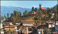
Kalimpong is a hill station (a hill town) nestled in the Shiwalik Hills
(or Lower Himalaya) in West Bengal, India. It is located at 27.06° N
88.47° E.
Kalimpong is well known for its many educational institutions, which
attract students from all over North East India, West Bengal, Bhutan,
Nepal, and Bangladesh. In recent times, Kalimpong has become an
important tourist destination owing to its temperate climate and
proximity to popular tourist locations in the region. |
| Places of Interest |
Panoramic snow views
Kanchenjunga, Siniolchu, Paunhari, Lama Anden, Chola, Nathu La, Jalep La
and Gymochen peaks. Best view points are Durpin Dara and Deolo Hill.
Flower, orchid and exotic flora nurseries
Gladioli, orchids, cacti, amaryllis, anthuriums, roses, gerberas,
dahlias and other exotic plants are grown in a number of flower
nurseries in Kalimpong, mainly for export.
Mangal Dhaam
This recently constructed place of worship is a marvellous piece of
architecture. The temple has been built in the memory of the late Guru
Shree 108 Mangal Dasji. The samadhi of the Guruji is located within the
temple.
Lava
34 kms away, hidden in mists and clouds, at an altitude of 2,350 Metres,
this small village, on the old trade route to Bhutan, is surrounded by
virgin pine forests. It has a lovely monastery of Bhutanese origin and a
Nature Interpretation Centre. Popular for nature exploration and bird
watching. It is also the starting point for trekking to the Neora
National Park, which is a storehouse of flora, wildlife and leads to the
3,152 metre high RacheLa tri-junction of Bhutan, Sikkim and West Bengal,
with a panoramic view of the Chola Range.
Lolegaon
Also called Kapher, is 25 kms from Lava, along a lovely forest drive. It
has a heritage forest and a view point for snow ranges of Singalila
Range.
Samthar Plateau
Scenic and remote plateau, at an elevation of 1,400 metres, it is 80 kms
from Kalimpong, and 45 kms from Lava. It has breathtaking snow views of
the entire range, superb sunrise and sunset, picture post card hamlets,
exotic flora, forests, mountain streams, river pools "far from the
maddening crowds". Popular for nature holidays, walking tours, angling,
mountain biking and nature and cultural explorations on foot.
Samco Ropeway
20 kms from Kalimpong on the highway to Siliguri, this ropeway was
constructed by Christian missionaries to spread the gospel. Spanning the
Teesta and Relli Rivers over 1 1/2 kms, it is a thrilling ride over 120
feet over the river with unforgettable views. It provides a second
access to Samthar Plateau, and for Forest exploration, and visit to
ethnic villages.
Teesta Valley
The main drainage of Sikkim, Kalimpong and Darjeeling region, it is only
14 kms from Kalimpong. It provides nature walks and river rafting, from
base at Chitrey, near Teesta Bazar. |
|